


Google has announced that all its satellite imagery of the Earth used in its Maps and Earth mapping products will be cloudless. If you were previously disappointed when zooming in on a map to see only a vague nebulousness the update should appeal to you. In other Google mapping related news the company are on the lookout for folk to trek around off-road with the Google Street View Trekker strapped to their backs.
Blue sky thinking
Google has announced it has upgraded the satellite imagery for all its mapping products “to celebrate the sunny days of summer”. The new imagery “virtually eliminates clouds, includes refreshed imagery for regions of the world where high-resolution imagery is not yet available, and offers a more comprehensive and accurate view of the texture of our planet's landscape”.
Inspired by NASA’s Blue Marble global image Google mined the hundreds of terabytes of satellite imagery available to it to produce a “seamless, globally-consistent image of the entire planet with a resolution of 15 meters per pixel”. Using computer analysis of a large number of overlapping imagery Google has been able to virtually eliminate camera artifacts, clouds and other atmospheric effects. The end result is an 800,000 megapixel global image.
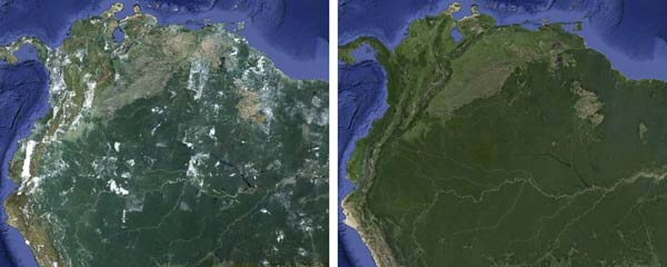
Interestingly, the maps show much more than just greater fidelity, the time lapse between the old images and these new ones clearly show the impact of humanity on the earth such as; agricultural expansion in Saudi Arabia and the continuing deforestation of Brazil.
Go for a hike, improve Google Street View
A new program announced by Google will allow third party organisations to borrow one of the Street View Trekker cameras. It’s best for you to look at this contraption rather than for me to describe it, a picture and video of some Trekkers is embedded below.
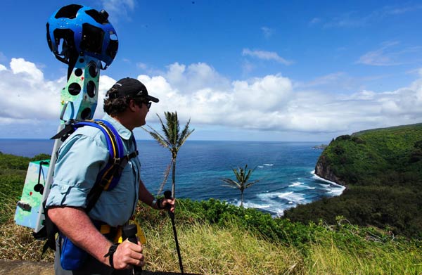
The Google Maps blog post tells us about a Trekker walking the Hawaii Volcanoes National Park and collecting fascinating panoramic imagery of these fascinating and beautiful islands.
Google close the blog post by inviting organisations such as “a tourism board, non-profit, government agency, university, research organization” or similar to capture and share the images of a place you know or care about. To become a Trekker fill in this form. The pilot program will kick off in the coming months.